
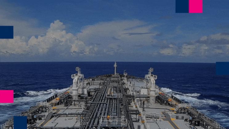
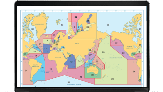
The ADMIRALTY Vector Chart Service (AVCS) is the most comprehensive, digital maritime chart service available; with over 15,800 Electronic Navigation Charts (ENCs) from hydrographic offices around the world, packaged and quality assured by the UKHO into a single value added service.
Key features include:
- Global ENC coverage with more major routes and ports than any other competing service
- Carriage compliant ENCs with certification to aid Port State compliance
- Unique ADMIRALTY Information Overlay (AIO) for additional passage planning information
- Operates on all ECDIS makes
- Weekly updates available electronically
Integrates with ChartWatch by EW Liner. Learn more about how to
order and maintain your AVCS ENCs using ChartWatch here.
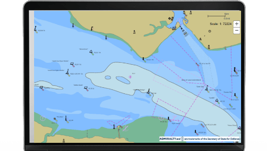
AVCS Online
A shore-based version of the world’s leading maritime chart service that is used on-board most ships trading internationally.
Key features include:
- Supports shore-based maritime decision-making including vessel tracking, planning and responses to accidents and emergencies
- Can be used by shipping companies, government agencies and other professional users who need a shore-based version of AVCS
- Provides world-leading coverage, including all available scales just like AVCS used on ships
- Has similar functionality as ECDIS, including pick reports where you can select a feature for more information
- Can be integrated into existing systems as a standalone chart solution, or as a base layer with other data layers added
- Uses internationally recognised Open Geospatial Consortium (OGC) standards and internet-accessible Web Map Service (WMS) protocols
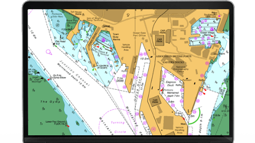
ADMIRALTY ARCS
The ADMIRALTY Raster Chart Service (ARCS) provides raster chart coverage of international shipping routes, main ports and harbours in a comprehensive range of scales. Ideal for both bridge crews and shore based users, it combines the familiarity of traditional ADMIRALTY paper charts with the precision of satellite positioning to support decision making.
Key features of ARCS include:
- Familiar, clear and easy-to-use digital charts, helping bridge crews to understand critical information at moments of peak workload and pressure
- Extensive coverage of international routes and ports in a comprehensive range of scales
- Weekly ADMIRALTY Notices to Mariners (NMs) updates to support safe navigation
- Compatible with a wide range of office based systems enabling cost-effective digital charting for shore-based users
If you are interested in finding out more about ARCS please contact us.
We can offer you guidance and support on how to purchase the ARCS service.
ADMIRALTY ECDIS Service
The ADMIRALTY ECDIS Service is an easy to manage, low administration, worldwide solution for those who wish to navigate digitally. It offers Electronic Navigational Charts (ENCs) found within the ADMIRALTY Vector Chart Service (AVCS) and raster charts found within the ADMIRALTY Raster Chart Service (ARCS) at a fixed annual price.
If you are interested in finding out more about the ADMIRALTY ECDIS Service please contact us. We can offer you guidance and support on how to purchase this service.
ADMIRALTY Digital Publications (ADP) are computer-based applications of the UKHO’s market-leading paper-based nautical reference guides – ADMIRALTY Nautical Publications.
They contain the same information as their paper equivalents, and are widely accepted as meeting SOLAS carriage requirements.
The full ADP range includes:
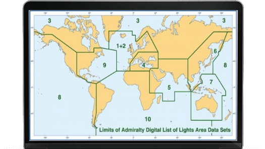
ADMIRALTY Digital List of Lights (ADLL)
An advanced source of navigational light and fog signal information, covering over 85,000 individual light structures worldwide, including lighthouses, lightships, lit floating marks and fog signals. ADLL contains all the details of the original paper editions, with the added convenience of fast, accurate weekly updates; substantially reducing the time and effort needed to keep it up-to-date.
You can order ADMIRALTY ADLL through
ChartWatch. Contact us to learn more.
ADMIRALTY Digital Radio Signals (ADRS)
ADMIRALTY List of Radio Signals is the world’s most comprehensive and authoritative source of information on all aspects of maritime radio communication. ADRS is easier to search and update compared to paper publications.
Aiding ongoing safety, security and compliance, ADRS helps bridge officers to manage communications and meet reporting regulations.
- ADRS 1, 3, 4, 5 – gives radio communications details for the relay of information on weather, safety, pollution, quarantines, Telemedical Assistance Services (TMAS) and GMDSS
- ADRS 2 – a range of compliant, digital positional and timekeeping references to help ensure ships are at the right place at the right time
- ADRS 6 – essential maritime radio communications information for over 3,800 service locations worldwide, including pilot services, Vessel Traffic Services and port operations
You can order ADMIRALTY ADRS through ChartWatch. Contact us to learn more.

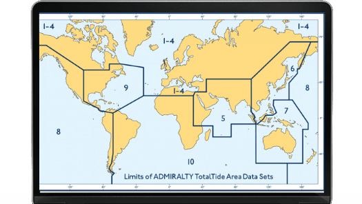
ADMIRALTY TotalTide (ATT)
ATT helps bridge officers take full advantage of favourable tides – allowing them to calculate safe clearances, making departure, arrival and transit planning easier. Reducing risks to ships, cargo and crew, ATT enables quicker and more informed decisions to be made on the bridge about key commercial and safety issues. By bringing global tidal height and tidal stream data together, complete with instant calculation, this helps bridge officers to make tidal predictions for ports and tidal stream stations worldwide.
You can order ADMIRALTY ATT through ChartWatch. Contact us to learn more.
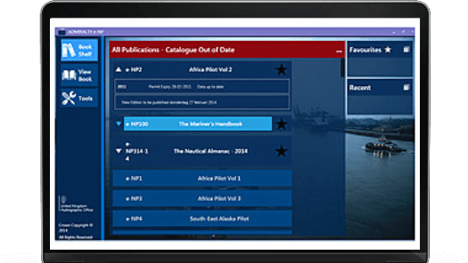
ADMIRALTY e-Nautical Publications
ADMIRALTY e-Nautical Publications (AENPs) are official ADMIRALTY Nautical publications available as e-books. Easy to use and update, they bring improved efficiency, accuracy and access to information bridge officers need. AENPs include the following:
-
Sailing Directions (pilots)
Provide essential information during port entry and coastal navigation, and are suitable for all classes of ships at sea, with worldwide coverage split into 75 volumes.
- Nautical Almanac (e-NP314)
- Guide to the Practical Use of ENCs (e-NP231)
- Guide to ENC Symbols Used in ECDIS (e-NP5012)
- Guide to ECDIS Implementation, Policy and Procedures (e-NP232)
- How to Keep Your ADMIRALTY Products Up-to-Date (e-NP294)
- Cumulative list of ADMIRALTY Notices to Mariners
- The Mariner’s Handbook (e-NP100)
- Ocean Passages for the World (e-NP136)
- IALA Maritime Buoyage System (e-NP735)
- Symbols and Abbreviations Used on ADMIRALTY Paper Charts (e-NP5011)
- Annual Summary of ADMIRALTY Notices to Mariners
Integrates with ChartWatch. Learn more about to order and view ADMIRALTY E-NPs using ChartWatch here.

Witherby Digital
The Seamanship Library - Digital Outfit Manager allows companies and individuals to build and customise their own digital library from over 600 industry e-books including publications from IMO, OCIF, SIGTTO, BIMCO, INTERTANKO, Shipping Guides and more.
We have a range of publications available as e-books on this website.